VRC Documentation
The Various Radar Modes
As of version 1.1, VRC offers ten different radar modes:
- Simple
- Ground
- Tower
- ARTS (Approach)
- STARS (Approach)
- DSR (Enroute/Center)
- VRC
- Park Air
- TAAATS
- PSR
- 3D
To switch among these modes, choose "Radar Mode" from the "Settings" menu. This will
display a sub-menu containing the ten modes.
If you have used ASRC, then you are familiar with some of these modes. The "VRC" mode, however,
is obviously unique to VRC. It is essentially a combination of the ARTS and DSR modes. New modes in VRC 1.1 include
Simple, Park Air, TAAATS, PSR and 3D. Detailed descriptions of each mode are found below.
Simple Mode
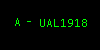
This mode is mainly intended to be used by Clearance Delivery controllers. Only the aircraft callsign is shown.
In VRC 1.0, this mode was called the Ground mode. Here are the different types of tags you'll see in Simple mode:
 |
Untracked, squawking normal. |
 |
Untracked, squawking standby. |
 |
Untracked, squawking VFR. |
 |
Tracked by Sector A. |
 |
Tracked by Sector A, tagged as voice-capable. |
|
Ground Mode
As the name implies, this mode is meant to be used by ground controllers. Tags include the callsign, aircraft
type, and ground speed. Here are the different types of tags you'll see in Ground mode:
 |
Untracked, squawking normal. |
 |
Untracked, squawking standby. |
 |
Untracked, squawking VFR. |
 |
Tracked by Sector A. |
 |
Tracked by Sector A, tagged as voice-capable. |
|
Tower Mode
As the name implies, this mode is meant to be used by Tower controllers. It is very similar to the ARTS mode (see
below) except all targets always have a full data block, even if they are squawking standby. Here are the different
types of tags you'll see in Tower mode, along with a description of the data in the tag:
 |
Untracked, squawking normal. The altitude (in hundreds of feet) and ground speed (in tens of knots) are shown in the second line.
The second line alternates between the alt/speed data and informational data. (See below.)
|
 |
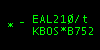
Untracked, squawking standby. The "/t" indicates that this aircraft has been tagged as text-only. |
 |
Untracked, squawking VFR. |
 |
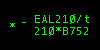
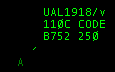
Notice the asterisk on the second line. This tells you that the data being shown is informational only, not actual data. The first field of the
second line (when in the informational phase) switches between the scratchpad and the filed altitude. If no scratchpad data has been
assigned to the aircraft, the destination airport is shown. The second field shows the aircraft type.
|
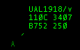
 |
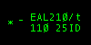
Second line in the information phase, showing the filed altitude as a flight level. |
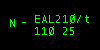 |
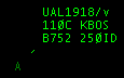
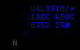
This target is being tracked by the controller covering Sector N. |
 |
This target is identing. The "ID" on line two flashes on and off for about 5 seconds. |
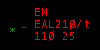 |
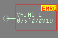
This aircraft is squawking 7700 to indicate an emergency. The "EM" flashes on and off. |
 |
This aircraft is squawking 7600 to indicate a radio failure. The "RF" flashes on and off. |
 |
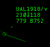
This aircraft has filed a VFR flight plan, as indicated by the V appended to the ground speed. |
|
ARTS Mode
ARTS mode is similar to the radar modes used in many TRACONs. ARTS and Tower modes are very similar, except that with
ARTS mode, aircraft can have either partial or full data blocks. Also, if a target is squawking standby, you'll see
no data block at all in ARTS mode. Here are examples of the differences between the ARTS and Tower modes:
 |
This aircraft is not being tracked by anyone and has a limited data block. If the aircraft were being tracked,
the asterisk target would change to a sector identifier letter, as with the Tower mode. In that case, the
partial data block will alternate between showing altitude and ground speed (as shown here) and the same
informational data as shown on line two of the full data block.
|
 |
This aircraft is squawking standby. No data block is shown at all.
|
 |
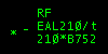
This aircraft is being handed off to the controller covering sector N.
|
 |
This aircraft has filed a VFR flight plan, as indicated by the V appended to the ground speed.
|
|
STARS Mode
STARS mode is very similar to ARTS mode. The primary difference is that the data in the tag rotates at a slower rate, and the primary
target symbol is a line that is drawn perpendicular to the closest radar station (defined by your visibility center(s) and changes in
size based on distance from that station. Also, when identing, the aircraft's full data tag flashes, instead of just part of it as in ARTS mode.
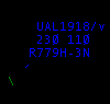
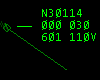
DSR Mode
DSR mode resembles the radar system used in many enroute traffic control centers. Full data blocks have three lines
instead of two. Also, additional information is shown regarding the aircraft's altitude, such as whether or not it
has reached its filed cruise altitude, or if it is currently climbing or descending. DSR mode also shows the aircraft
CID (computer ID) in the data block. The CID provides another way to select aircraft. (See "Selecting Aircraft".)
Here are the different types of tags you'll find in DSR mode:
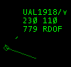
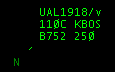
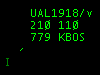 |
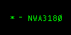
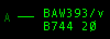
This target is not being tracked by anyone. The first line shows the callsign and voice type tag. The second line
shows the filed cruise altitude and the current altitude. The third line shows the aircraft Computer ID (CID)
and the scratchpad. If the scratchpad is blank, the destination airport is shown. This last field alternates
among the scratchpad, the groundspeed, and the aircraft type.
|
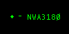
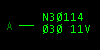
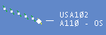
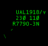 |
This target is being tracked by another sector. The two-character sector ID is shown in the last line
just after the "O-". In this case, the owner's sector ID is "3N". This sector
ID corresponds to the two-character index you see next to the controller's callsign in the Controller
List.
|
 |
This target is owned by you. Notice the diamond around the target and the vector line. The vector
line predicts where the aircraft will be in the future. The length of the line is either a fixed
number of nautical miles, or it is calculated based on the aircraft's current ground speed and ground
track. See "Configuring VRC" for details on configuring the vector line.
|
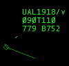 |
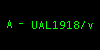
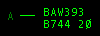
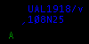
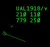
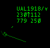
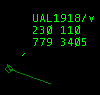
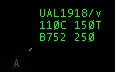
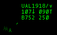
Notice the "T" in the second line. This indicates that the first field (090 in this case) is
an assigned temporary altitude.
|
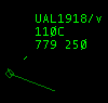 |
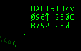
When the second line just has a single number followed by the letter "C", that means that
this aircraft has reached its filed cruising altitude. (Or is at least within 300 feet of it.)
|
 |
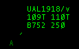
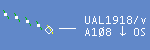
This aircraft is at 11,200 feet and climbing. (Notice the arrow.)
|
 |
This aircraft is at 11,800 feet and descending. (Notice the arrow.)
|
 |
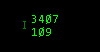
This aircraft is squawking VFR. The single number is the altitude in feet.
|
 |
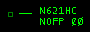
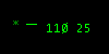
This aircraft is squawking standby.
|
 |
This aircraft is squawking normal, but has only a limited data block. The data shown is the aircraft's
squawk code and its altitude in hundreds of feet.
|
 |
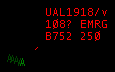
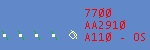
This aircraft is squawking 7700, indicating an emergency.
|
 |
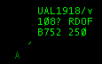
This aircraft is squawking 7600, indicating a radio failure.
|
 |
This aircraft is identing. Notice the three hash marks drawn across the target.
|
 |
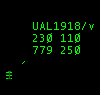
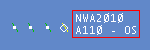
This aircraft has a squawk code that is a duplicate of another aircraft's code.
|
 |
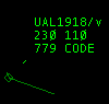
When you see a squawk code displayed in the second field of the third line like this, that means that
the aircraft is not squawking its assigned code. The code shown is the code the aircraft is actually
squawking.
|
 |
This aircraft is being handed off from the controller identified by sector ID "3N".
The data block flashes until the handoff is accepted, cancelled, or refused.
|
 |
This aircraft is being handed off to the controller identified by sector ID "3N".
|
 |
This aircraft has filed a VFR flight plan, as indicated by the V appended to the ground speed.
|
|
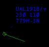
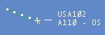
VRC Mode
The VRC radar mode is not modelled after any real-world radar system. It was designed to show certain pieces of
information at all times, while rotating the less-critical data items in a single field. The main idea is to have
the altitude, ground speed, and aircraft type available at a quick glance without having to wait for them to rotate
into view. Here are the different types of tags you'll encounter in VRC mode:
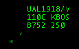 |
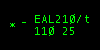
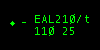
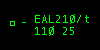
This aircraft is not tracked by any controller. The first line contains the callsign and voice type tag.
The second line contains the current altitude in hundreds of feet, and the scratchpad. If the scratchpad
is blank, the destination airport is shown. The "C" next to the altitude means the aircraft
is within 300 feet of its assigned cruising altitude. The third line always shows the aircraft type and ground speed.
|
 |
This aircraft is owned by the controller covering sector N. (Which could be either you or another controller.)
|
 |
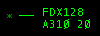
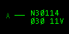
This aircraft is owned by the controller covering sector A, and it has an assigned temporary altitude of 15 thousand feet.
|
 |
This aircraft is within 300 feet of its assigned temporary altitude.
|
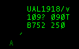 |
This aircraft has reached neither its filed cruise altitude nor its assigned temporary altitude, and
it is neither climbing nor descending. The question mark indicates that the pilot seems to have levelled
off at an unassigned altitude.
|
 |
This aircraft is at 10,700 feet and descending. It also has an assigned temporary altitude of 9,000 feet.
|
 |
This aircraft is at 9,600 feet and climbing. Its assigned cruise altitude is FL230.
|
 |
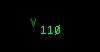
This aircraft is squawking VFR. The single number is the altitude in hundreds of feet.
|
 |
This aircraft is squawking standby.
|
 |
This aircraft is squawking normal, but has only a limited data block. The data shown is the aircraft's
squawk code and its altitude in hundreds of feet.
|
 |
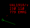
This aircraft is squawking 7700, indicating an emergency.
|
 |
This aircraft is squawking 7600, indicating a radio failure.
|
 |
This aircraft is identing. The "ID" on the third line flashes on and off.
|
 |
This aircraft has a squawk code that is a duplicate of another aircraft's code.
|
 |
When you see a squawk code displayed in the second field of the second line like this, that means that
the aircraft is not squawking its assigned code. The code shown is the code the aircraft is actually
squawking.
|
 |
This aircraft is being handed off from the controller covering sector N.
The data block flashes until the handoff is accepted, cancelled, or refused.
|
 |
This aircraft is being handed off to the controller covering sector N.
|
 |
This aircraft has filed a VFR flight plan, as indicated by the V appended to the ground speed.
|
|
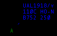
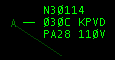
Park Air Mode
The Park Air radar mode simulates the radars used by many approach controls in the UK. Here are the
different types of tags you'll encounter in Park Air mode:
 |
This aircraft is tracked by me, as indicated by the hollow diamond target symbol. The second line shows
the altitude in hundreds of feet, as well as a climbing/descending/level indicator, and the "intention code"
which is the last two characters of the scratchpad, or destination field. Note that the altitude is prefixed with
either an A to specify an altitude (below the transition level) or an F to indicate a flight level.
|
 |
This is an untracked aircraft. The target symbol is a cross.
|
 |
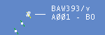
This aircraft is tracked by another controller, as indicated by the filled diamond target symbol.
|
 |
This aircraft is coasting. The target symbol is a hash mark.
|
 |
This aircraft is squawking a VFR code, and climbing. The first line is the squawk code, and the second line is the altitude.
|
 |
This aircraft is squawking standby, or is filtered out.
|
 |
This aircraft is tracked by me, and is descending.
|
 |
This aircraft is in conflict. The red box around the datablock flashes.
|
 |
This aircraft is squawking emergency. The squawk code flashes.
|
 |
This aircraft is squawking radio failure. The squawk code flashes.
|
|
TAAATS Mode
The TAAATS Radar Mode simulates the look of the Australian Air Traffic Control System. Based on Eurocat, it
uses colours and shapes differently from traditional radar to provide more information on the state of each aircraft.
While it is impossible to mimic the consoles exactly, many key features and components are simulated in this mode.
Key Differences:
- All targets with transponder on (Mode C) will be tagged (unless the filter is used to supress them)
- Colours are used to indicate ownership. NOTE: Colours are hardcoded at this time
- Target shapes are used to indicate tracking modes and flight state
- Mouse Wheel-click on callsign toggles between full and limited datablock
- Voice flag is shown in last (expanded) line of datablock
 |
Targets tracked by me are pale green.
|
 |
Targets tracked by someone else are blue.
|
 |
Targets tracked by noone are black.
|
 |
Targets being handed off are salmon.
|
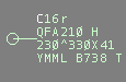 |
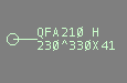
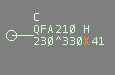
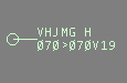
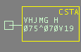
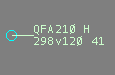
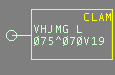
This is a full data block. Reading from the top left,
the coordination flag 'C' indicates the aircraft is my request list. '16r' is the scratchpad entry.
Line 2 contains the aircraft callsign, QFA210, then the wake category of the aircraft; L=Light, M=Medium, H=Heavy.
The third line contains the current altitude, FL230, the trend indicator (^ = climb, > = maintaining, v = descending), then the assigned altitude of FL330, RVSM status 'X', and airspeed in 10's of knots (41, = 410kts).
The 4th line indicates the destination, YMML, and aircraft type, B738, and the VATSIM voice flag, 'T'.
|
 |
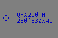
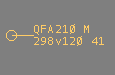
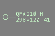
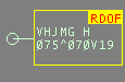
This is a limited datablock, the default type of datablock presented. The aircraft is still on my request list, but the scratchpad is empty. Limited datablocks do not display the 4th line containing destination and aircraft type. To toggle the 4th line on and off, mousewheel-click on the datatag.
|
 |
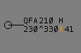
The RVSM indicator, between the assigned altitude and airspeed, shows whether the aircraft has filed as RVSM capable. A blank indicator shows the aircraft can fly RVSM levels. An 'X' indicates the aircraft has filed IFR and is NOT RVSM equipped. A 'V' indicates the aircraft has filed VFR (and hence is NOT able to fly RVSM).
The indicator turns orange when the assigned level and/or the actual altitude are in the RVSM band. Outside the band, it reverts to the datablock colour.
|
 |
This aircraft has filed and is operating VFR, as can be seen by the 'V' between the assigned altitude and the speed. The target appears as a circle as it has been given a discrete code (but is continuing to operate VFR). It is still VFR, therefore NOT RVSM compliant.
|
|
This aircraft is squawking a discrete code, therefore the target is a circle. It is being controlled by me, so it is green.
|
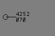 |
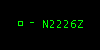
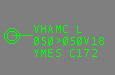
This aircraft is also squawking a discrete code, so appears as a circle. The code has not been associated with any aircraft, so only the code and the altitude are reported. It appears black as it is not controlled by anyone.
|
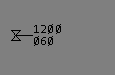 |
This aircraft is squawking the generic VFR code (1200), therefore the target is an hourglass. It appears black as it is not controlled by anyone.
|
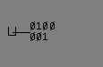 |
This aircraft is squawking the generic special code (0100), therefore the target is a 'U'.
|
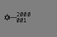 |
This aircraft is squawking the generic special code (2000), therefore the target is a star.
|
 |
This aircraft is coasting (network updates lost) so the target appears as a square. The 'Coast Alert' has also been annunciated.
|
 |
This aircraft has been Selected - note the octagon around the target. Aircraft tracked by me turn bright green when selected. Aircraft not tracked by me turn white when selected.
|
 |
This aircraft is squawking Ident - the target symbol blinks a cyan colour.
|
 |
This aircraft is more than 400ft from its assigned altitude and is moving away. The Cleared Level Alert Monitor is annunciated. This only appears for aircraft under my control.
|
 |
This aircraft is squawking 7600, a radio failure.
|
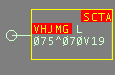 |
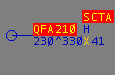
This aircraft is in conflict with another. The Short Term Conflict Alert condition is annunciated and as this aircraft is under my control, the datablock is bordered. Note I will only see an SCTA if one or more of the aircraft is under my control.
|
 |
This aircraft is in conflict with one of my aircraft; as it is owned by another controller, no border is displayed around the datablock.
|
 |
This aircraft is squawking 7700, Emergency.
|
|
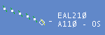
PSR Mode
PSR stands for "Primary Surveillance Radar". In this mode, only a primary radar return is shown, depicted as a slash.
This primary return is also known as a "skin paint". It is a representation of the radar energy being bounced back
to the radar antenna by the fuselage of the aircraft. This mode is intended for controllers using special procedures for facilities
that only have basic radar and no SSR (Secondary Surveillance Radar) systems with which target callsign and flight plan data can be correlated.
 |
All aircraft in PSR mode are displayed the same way ... just a simple primary radar return as shown here.
|
|
3D Mode
The VRC 3D radar mode is quite different from the other radar modes. Whereas the other modes provide a "top down" view, the 3D mode
provides a three-dimensional view of your airspace and sector file information. This mode is ideal for providing a very simple "out-the-window"
view for Tower and Ground controllers.
You are able to pan the camera by holding down the right mouse
button and moving the mouse. You can also zoom the camera in and out using the mouse wheel. If you wish to move the location of the camera, hold
both the left and right mouse buttons, and move the mouse. You can raise and lower the camera height by holding the CTRL key and rotating the
mouse wheel. The .set3dalt command can also be used to set the camera altitude. For example, the following command
will set the camera altitude to 300 feet:
.set3dalt 300
You can set the terrain height as well. The terrain height is the altitude MSL at which all the data in your sector file are drawn. You should set
this to the airport elevation for the field where you are controlling. The command to set the terrain height to 1200 feet would be:
.setterrainalt 1200
You can also use a dot command to move the camera to a specified location. For example, to move the camera to the Manchester VOR, you
would use the following command:
.set3dcenter MHT
You can also lock the camera onto a specific target using the .lockview command. For example, if you
wanted to lock the camera onto the currently selected aircraft, you would type .lockview followed by
pressing your aircraft select key. To unlock your view, simply type .lockview followed by the Enter key.
The targets in 3D mode have simple one-line data tags that rotate between the callsign, the altitude and speed, and the aircraft type and destination.
Note that targets and tags are not clickable in 3D mode. You'll need to use another scope window, the strip bay, or the ASEL key to select aircraft on a 3D mode scope.
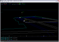 |
Click the thumbnail at left to see a screenshot of the 3D view. This screenshot shows a view of the approach end of runways 22R and 22L at
Boston Logan airport. There is one aircraft taxiing out for departure, one aircraft holding short of runway 22R, and one aircraft on short
final for runway 22L. You'll notice that a line is drawn from the aircraft down to the ground level in order to give an altitude reference.
|
|
Notes
- If you have multiple Display Windows open, you can set the radar mode separately in each one.
- In all modes that have a datablock, you can reposition any aircraft's datablock by clicking and dragging it.
- The colors used in the TAAATS and Park Air radar modes are hardcoded. Changes to your color selections will not affect these modes.
© Copyright 2005 Ross Alan Carlson - All Rights Reserved